Brian McInerney is a former chief hydrologist for the State of Utah. He has come out of retirement to consult for Salt Lake County concerning how to best handle the massive runoff we are about to receive. McInerney appeared as a guest on a Utah Stories podcast where he offered several insights. The unprecedented nature of this year’s snowpack is due to a few factors. Usually, there are just two major atmospheric rivers that might dominate the weather pattern in January, but this winter saw around 30. These “rivers” have dumped more than 900 inches of snow. Why now? Is this due to climate change?
“It could be,” McInerney says. “For every degree centigrade, you raise the atmospheric temperature, you get a seven percent increase in atmospheric moisture.” Heat has a compounding impact on the amount of moisture clouds can draw from the Pacific.
“It’s literally ten times the carrying capacity of the Mississippi River in one band, in one atmospheric river,” he explains. “And it’s low-level moisture and it takes just a little bit of a bump for it to go up, and that is usually the mountains of California, and then it precipitates out a phenomenal amount.”
How Much Water Still Needs to Melt Above The Wasatch Front?
More Highlights from Brian McInerney about our current snowpack and potential for flooding:
“Currently, some of these drainages along Salt Lake like City Creek is up to 500% for this time of year. At 6,800 feet typically your snowpack is going to be totally melted out within maybe a week. And right now we’ve got 500% of what you typically get. Granted, the percentages go up really fast because we’re almost dropping out, but we have like 36 inches of water sitting up on that hill that needs to be melted out.”
What Are “Isothermal” Melting Conditions And Why it Is Important to Our Watershed?
“Another thing with the giant snow pack we have this year is it’s frozen up. It’s not isothermal, meaning there are cold pockets in there. So if you get melt on the very surface of the snow and it starts to infiltrate into the snowpack, it’ll hit those cold pockets and just freeze up again. So you don’t really have much coming out until it’s 32 degrees Fahrenheit, top to bottom, or zero degrees centigrade.”
“And once that melts from the top can trickle through and make it to the surface, and now you’ve got really good conditions. So it doesn’t evaporate, it doesn’t transpire, it just makes its way into the creek. It’s very efficient. Our problems are in the low years as we melt early, so it becomes isothermal way too soon. You get meltwater coming out of the snowpack and then it just evaporates.”
What is the Worst-case Scenario When it Comes to our Meltdown?
The worst-case scenario is we start melting snow at two inches per day. We crank the temperatures up to 80, or 90 degrees and we have bright sunshine with no clouds. And then we get a long-duration, widespread low-elevation rain event that just soaks everything.
Rich (20:10):
So high temperatures followed by rain. That’s what we don’t want?
Yeah because think of the mountains right now, or in about a week from now, they’re going to be putting out an inch-per-day melt all across where you see snow. So under there, an inch of water is coming down and the channels can hold that. What if we rain two inches wide across the entire basin? Now theoretically we’ve got melt rates up to three inches per hour. The channels aren’t used to that. They’re not formed by flows they see like that. And then put on top of that consecutive 24-hour melt cycles, we’ll just have too much water. The most optimal scenario is we pick it up next week, we have melt rates of about an inch to an inch and a half per day for about a week. And then maybe we slow it down a little bit, let it drain out a little bit, maybe two days of cloud cover, maybe a little cooler temperatures, then bring it back up, pick the melt up to an inch and a half per day and then slow it down again. Yeah, pick it up again until we’re basically out of low and mid-elevation snow. Even if you have high-elevation snow, it’s still, when you think of the mountains, the aerial extent it gets smaller is the higher you go until you’re standing on top of the peaks around there. High-elevation snow is still okay because then you don’t have as much snow. It’s that mid-elevation. And right now that’s the problem because we have so much snow at that mid-elevation, 7,000 feet like you mentioned earlier.
Rich (21:40):
So if say the worst case scenario happens and we get up to two inches of melt – another inch on top with rainfall, will everybody’s houses potentially see flooding? Will all of our streets be covered in water?
Brian (21:55):
No, no, we won’t see that. What you’ll see is overbank flows…
Rich (22:01):
Just the people next to the river are in danger?
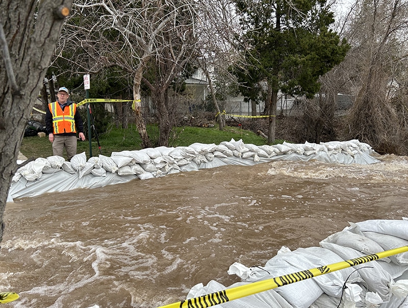
Yeah. Around there. You will probably see some problems with basement flooding, but it’s the people who live around the streams or some of the intersections and roads that are around the stream. We’ll see overbank flows over the roads most likely. But since I have transitioned from working with the weather service to retiring for three years and now I’m consulting with Salt Lake City as a hydrologist. I’ve learned that they’ve got so much infrastructure that they can really alleviate a lot of problems that when I was just starting back in the nineties wasn’t the case. There just wasn’t. They’ve engineered a lot of this. They have game plans on how to do this. The engineers meet frequently just to game plan this and figure out where their choke points are, where the narrowing [is], where they’re going to have problems, and then they stage equipment at these locations to get things out quick. The biggest problem, along with the scenarios that we’re talking about, is if you have a jam in one of the streams. Then that kind of changes the trajectory of the water. I think Emigration is a really good example of how they controlled that so fast. The engineers got out there, they had help putting out sandbags and channeling that water.