Hidden Utah

The Hermit of Marjum Pass

A brokenhearted Bob Stinson left society behind and built a life in a natural cave in Millard County, not far from Delta. The remains of his home can be found in Marjum Canyon.

|


When the obituaries of Delta, Utah recounted the life of Bob Stinson, it told a tale of a man who lived up to his namesake — the “Hermit of Marjum Pass”:

“His home was made in Marjum Pass alongside the highway 60 miles west of Delta. He was the only resident of the area … During the years, many wayfarers and friends enjoyed Bob’s hospitality in the snug quarters he had made by adding an outside wall to a roomy cave.”

Now, like the dwellings of the natives constructed long before the pioneers arrived, Stinson’s home sits in the lonely West Desert of Utah. His story is not one of chance, but a consequence of heartbreak and a desire for solitude, and the community that came around him after. 

Not much is known about Stinson except for his obituary and an occasional mention online or in travel guides. Born on April 21, 1880, in Marion, Iowa, Stinson later served in World War I. Upon his return, he was heartbroken to discover his fiancée had married another. Devastated, he ventured west to Utah in 1929 to visit his brother, Roy. It was during this journey that Bob’s “mobile home” gave out, leaving him stranded in Marjum Pass, forcing him to make an unexpected choice: he stayed put. 

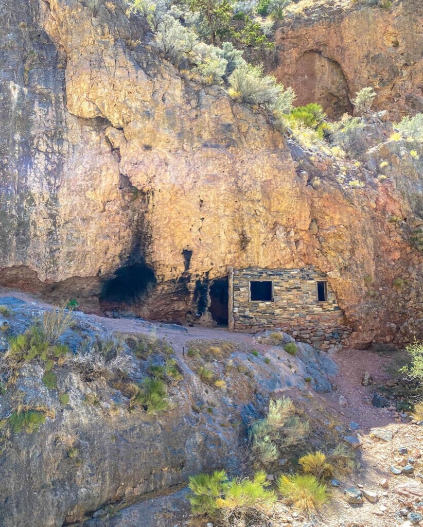
He transformed a natural cave, cleverly using rocks to make a front wall and shielding the interior from the elements. Over time, he did extensive work on the cave, pouring a concrete floor, carefully carving windows and rock shelves and adding a bedframe and mattress. These features can still be seen today. 

Located deep within Marjum Canyon, 45 miles from Delta, Hermit’s Cabin sits alongside dirt roads, snaking through sagebrush that stretches for miles. The air around the cabin is quiet, and at night the stars punctuate an endless sky — a glimmering ceiling atop the canyon. When the wind stops, the silence is profound and seems to spread out along the sagefields, leaving little question as to why someone would want to homestead there. 

During Stinson’s time, this area served as an east/west connection, linking Delta to Nevada and all the way to California. Today, it’s the definition of a road less traveled, with only a handful of cars passing through each hour. Most are local residents or visitors looking for solitude, like Stinson was (as well as rocks to hound and mines to explore). 

J.B. Cram, with the Bureau of Land Management, reflects on the type of life Stinson likely found in this part of Utah: “A thought that comes out is that of the solitude that can be found on public lands. Public lands are all unique, and everyone can find the kind of solitude they are seeking on them. That is the purpose of these unique areas; for each person to find their place.” 

Though he lived in solitude up Marjum Pass, Stinson’s connection to the Delta community was evident and grew year after year. Residents say he trapped and tended to a flock of sheep, and for years was entrusted by the Bureau of Land Management to clear the pass of debris and do other odd jobs. His innate hospitality always shone through, as every visitor was greeted with his legendary home-brewed beer. 

Few photos of Stinson exist or remain today. Stinson’s main legacy is in the rock wall and homestead he built while isolated in the desert. For the most part, it has remained intact and endured the test of time. 

“Over the years, some pieces have been placed and removed from the cabin from its original state,” says Cram. He reminds visitors to “Leave no trace, and pack out what you pack in.” 

Kevin Morris, with Millard County Tourism, says the area is a fun place for visitors to explore, but a good quality vehicle and a little prep are needed due to rough road conditions.

“Some of the roads can be rocky out there,” Morris says. “We encourage people to bring an extra spare and lots of water when they go out there.” 

How to get to Hermit’s Cabin (From the BLM): 

DIRECTIONS: From Delta, travel west on highways 6 & 50 for 33 miles, then turn right at the U-Dig Fossil sign. Travel north on the gravel road for 10.4 miles to a 4-way intersection. At this intersection, turn left to the Marjum Pass, then drive west for 12.8 miles. The rock house is located in a narrow canyon, which is the last small side canyon on the north side of the Marjum Pass. 

Have fun exploring!

Location: LATITUDE/LONGITUDE: 39.247166, -113.402867

Feature Photo: Home constructed by Bob Stinson from a small natural cave that he enclosed by using local rock. Photo courtesy of Millard County.

,


Join our newsletter.
Stay informed.


  • From Immigrant Miner to U.S. Senator: The Rise of Thomas Kearns in Park City

    In June of 1883, 21-year-old Thomas Kearns arrived in Park City with little to his name and no guarantee of success. Like many young men drawn to the mining camps of the West, he was poor, ambitious, and willing to take whatever work he could find. After months of grueling labor underground as a mucker in the Ontario Mine, Kearns distinguished himself through persistence and curiosity, spending his evenings studying manuscripts on mining and land rights long after his shifts ended.

    That quiet discipline soon changed his fortunes. A chance observation while tunneling led Kearns and a small group of partners to lease nearby claims, uncovering one of the most productive silver deposits in Utah history. In less than a decade, the immigrant laborer had become a millionaire and a central figure in Park City’s economy, setting in motion a rise that would carry him far beyond the mines.

    To access this post, you must purchase Utah Stories (Digital + Print) or 3 month free trial (Digital).


  • Why Price, Utah, Needed a Rock and Fossil Shop

    After years in Salt Lake City and an interlude in Oregon, Kathie Chadbourne settled on Price as the location for her new rock shop. The town appealed to her because of its strong ties to geology and archeology, and its place within the Dinosaur Diamond. At first, she wondered whether a shop like hers might already exist there.


  • Highway 6 and the Midland Trail: Utah’s Transcontinental Highway History

    From Price Canyon to Delta’s desert stretch, Utah played a central role in building the Midland Trail, one of America’s earliest transcontinental highways and the foundation of today’s Highway 6.


  • Whiskey, Bullets & a Buried Town: Archaeologists Reveal Alta’s Wild Past

    Before Alta was known for powder days and lift lines, it was a silver mining town clinging to the side of a narrow canyon. In the late 1800s, men lived at 8,000 feet, went underground each day, and endured winters that regularly buried buildings in snow. This past summer, that mining town resurfaced — literally — during construction at the Alta Ski Area.

    To understand what Alta really looked like, you don’t begin with legend. You begin with its trash — and this time, that happened almost by accident.

    Alta Ski Area was installing underground water reservoirs to support snowmaking. Because the project sits on Uinta-Wasatch-Cache National Forest land, an archaeologist was required to monitor the excavation. No one expected the trench to produce much.

    But, It did.

    Artifacts began surfacing almost immediately. Enough that the Forest Service contacted the Utah State Historic Preservation Office for help. Lexi Little, who coordinates the Utah Cultural Site Stewardship Program, helped mobilize nearly 30 volunteers to assist with what quickly became a focused two-week excavation.

    Winter deadlines were approaching. The pipes for the reservoirs had to go in the ground. There wasn’t time for a slow, extended dig.

    “It was two weeks of digging in the dirt and helping figure out exactly what we were looking at,” Little said.

    Most of the people screening soil weren’t professional archaeologists. They were trained stewards from around Utah — part of a statewide volunteer network that now approaches 500 people. They poured dirt through shaker screens, scanning for fragments that could piece together a town long buried.

    “Archaeology is human trash,” Little explained. “Archaeologists are very into trash.”

    Alta had left plenty behind.

    https://youtu.be/hzIHzx3OGoo?si=dKcl2CEz-t6FZzYw

    Victorian-style ceramics appeared first — the kind typically used in hotels. Medicine bottles followed. Ink bottles. Hand-blown glass. A porcelain doll’s foot surfaced from the soil, a small detail that shifted the mental image of the town. Families were here. Children were here. This wasn’t only a camp of miners.

    The bottles helped establish time. Manufacturing details — whether glass was hand-blown or mold-made, whether a maker’s mark appeared on the base — allowed archaeologists to date many of the artifacts to the 1870s through the 1890s, when Alta was booming as a silver mining town.

    “That gives you that range of dates for when Alta was really booming,” Little said.

    One reusable soda bottle clearly stamped “Salt Lake City” connected the canyon to the valley economy below.

    Then something unusual rolled out of a dirt pile.

    A corked bottle. Intact. Liquid still inside.

    To access this post, you must purchase Utah Stories (Digital + Print) or 3 month free trial (Digital).