It’s no secret that Salt Lake City is experiencing a tech surge.
In fact, in 2018, the Capitol City had the second-most tech-related commercial leases and now holds the ninth-largest share of tech renters in the country, according to data from Cushman & Wakefield, a Chicago-based commercial real estate company.
But back in 2014 when Nearmap, an Australian aerial imaging and data company, decided to make the jump to North America, Utah was not nearly as hot of a market.
“The original idea was San Francisco, but it was expensive and difficult to recruit there if you weren’t part of FANG [Facebook, Amazon, Netflix and Google],” says Taylor Cenicola, Nearmap’s public relations manager. “Our previous CEO decided on Utah. It was an up and coming area. I think it’s pretty cool that he had that foresight.”
Nearmap opened its U.S. headquarters in South Jordan, growing its employee base to nearly 80 employees over the subsequent years.
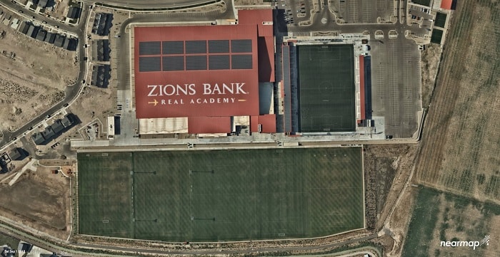
Using a fleet of aircrafts fitted with patented camera technology, Nearmap has evolved from a small startup to an international company innovating in the field of aerial imaging and data.
The planes fly over roughly 71% percent of the U.S., capturing incredibly high-definition aerial images that can be used to glean data about terrain or existing buildings for a range of industries, from roofing and solar to government and utilities.
“Our biggest segment is architecture, construction and engineering,” says Cenicola. “We wanted to change that people work and how they consume aerial imagery and data.”
Previously, says Cenicola, businesses would have to commission a plane, pilot and crew to fly a parcel of land and it could take months to get the imagery due to the sheer volume of data. But Nearmap flies over its coverage areas on a set schedule several times a year and loads the images to the cloud within days, so businesses always have a current view of what’s on the ground.
And Nearmap continues to push the boundaries of what information you can gather from the air.
“Instead of just vertical imagery, we now have panorama, obliques and 3D,” says Cenicola. “We actually just announced in June our AI [artificial intelligence] product, which is something we are continuing to develop.”
Just as Nearmap has continued to grow over its five years in Utah, so has Salt Lake Valley’s tech footprint. In fact, a side-by-side comparison of Nearmap’s aerial imaging of Lehi captured in 2014 and 2019 shows just that.
“It’s something that’s pretty exciting,” says Cenicola. “There’s an abundance of talent here and as we continue to grow, it’s important for our success to have the right people.”
Experience a time-lapse video of Lehi from 2014 to 2019 from Nearmap here.